In this short photographic tour we
start in the east Kimberley and present a fleeting impression
of the region as seen by a non-Indigenous photographer.
Many of these photographs were taken on foot in remote
areas, but we start with a place - the Bungle Bungles
- that is now more accessible, at least in Kimberley terms!
However, until the mid 1980s it had barely been heard
of by the outside world.
|
|
|
|
The Bungle Bungle region has supported a rich Aboriginal
culture for at least 20 000 years. People with an interest
in the country speak Kija, Miriwoong, Jaru and other languages
and tended to live along the rivers, creeks and waterholes
of the area. One of the artists featured on this Website,
Jack Britten, is a senior Kija lawman and uses designs
from his country and paints using ochres derived from
its earth.
|
|
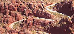
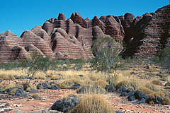
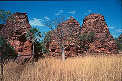
When the Kimberley region is mentioned, most Australians
would think of the Bungle Bungles' striking beehive-shaped
domes and deep gorges. They were formed around 20 million
years ago by water action on much older sandstones and
conglomerates. The characteristic striping is the result
of layered staining by blue-green algae.
|
|
| |
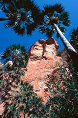
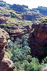
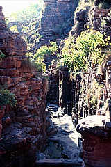
Deep within the domes are narrow chasms and gorges - in
places the sheer walls narrow down to passages with walls
only a metre apart. In the wider gorges, Livistona palms
provide elegant fans of greenery. These plant communities
are relics of previous wetter times when lusher vegetation
covered the region. Throughout the Kimberley there are
pockets of relict vine thicket and rainforest around pools
and springs providing shelter for birds and animals. These
were also popular places for Aboriginal people to visit
or relax in, especially during the hot dry season.
|
|
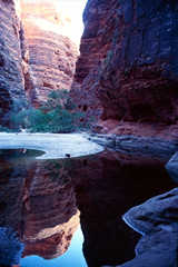
Cathedral Gorge in the Bungle Bungles
leads to a wide still pool in the dry season. During the
Wet, it would be impossible to reach this point as the
gorge would be filled with raging torrents many metres
deep, swirling and scouring the sandstone into its rounded,
convoluted shapes. Animal tracks are often observed at
these pools as they come in to drink.
|
|
| |
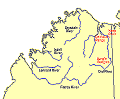
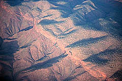
Leaving the Bungle Bungles and flying north along the
valley of the Ord River and the ranges to its west, the
country becomes even more wild and rugged. Here the Carr
Boyd ranges, north of the huge Argyle diamond mine, lay
spread out in the late afternoon sun of a hot and hazy
day in the late dry season. The haze comes from dust and
the fires that occasionally result from lightning strikes
at this time of year.
|
|
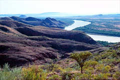
The Ord River is one of the immense rivers of the Kimberley.
These rivers are quiet in the dry season, sluggishly moving
across sandy beds or through long still pools and waterholes
lined with paperbark trees and pandanus. But in the wet
season they spread across the country in swift moving
silver and grey masses.
|
|
| |
To the east of the Ord River, straddling
the border between Western Australia and the Northern
Territory, is the Keep River region. The landscape here
is similar to the Bungle Bungles, with deeply dissected
sandstone gorges and pockets of rainforest. Walking in
this country can be very difficult and confusing!
|
|
The native kapok tree provides a brilliant
splash of colour in the dry season as it flowers on the
bare branches. These trees are deciduous and are one of
the first to drop their leaves at the end of the Wet.
After flowering, the trees form fat green pods that later
burst to distribute hundreds of fine seeds with silky
hairs attached.
|
|
| |
The scenery of Keep River is reminiscent of the Bungle
Bungles with the round sandstone domes. There are also
large areas of speargrass reaching above head height -
and of course boab trees. The young boab in this picture
may one day grow to become one of the gnarled, spreading
giants that dot the landscape.
|
|
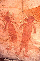
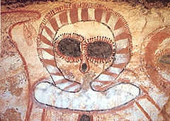
These large figures are painted on
the roof of a rockshelter in the Keep River region more
than 3 metres above the ground. They represent the first
Miriwoong men, the giant Gangi Nganang. Stylistically
these figures are a link between the Wandjina figures
further west in the Kimberley and the large creation figures
of the Victoria River region to the east. |
|
| |
West of the Ord River is the Cockburn
Range, a plateau shaped like a vast round fortress of
high orange cliffs and drained to the north by a narrow
gorge. This gorge is enclosed with thick vine rainforest
in which pythons live - and in the water there are numerous
fish, turtles and freshwater crocodiles.
|
High under the cliffs of the Cockburn Range,
where the creek drains out from the plateau, there is a
large and beautifully preserved gwion
gwion (commonly known as a Bradshaw) figure. The
male figure has a concentric headdress and is holding a
boomerang ready to throw, with six others in the other hand,
while beneath him there are four smaller female figures.
|
|
| |
Flying west, we pass over the mouth
of the Ord River and across the immense tidal mud flats
of Cambridge Gulf. As we go further west, we pass over
the King George River and its huge waterfalls dropping
sheer into the ocean and on to the Mitchell and Drysdale
Rivers - the heart of Wandjina country. The West Kimberley
is the subject of part 2 of our photographic tour, coming
soon.
|